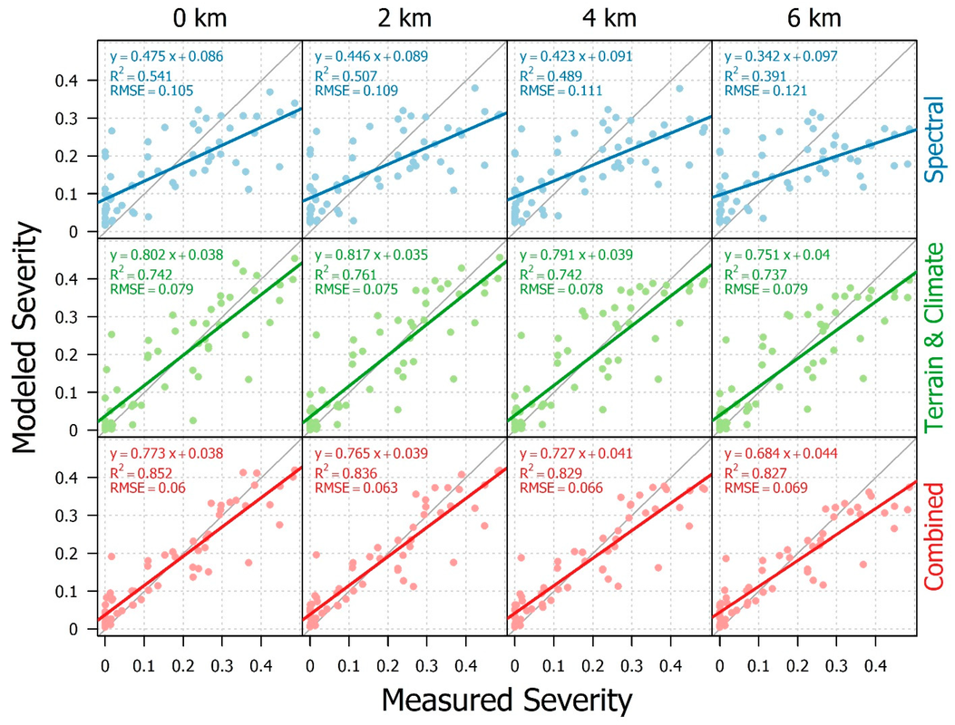
Mapping Balsam Woolly Adelgid InfestationThe Balsam Woolly Adelgid has infested fir forests of the US for over a century, yet methods for reliably mapping its effects have remained elusive. The temporally drawn out, spatially diffuse, and spectrally subtle nature of BWA-induced damage makes quantifying the insect's damage particularly challenging. Through the combined use of a Landsat time series, topography, and downscaled climate data, we demosntrated an impressive capacity to model and map BWA infestation severity in the forefront of BWA spread in the US: northern Utah.
Click here to access the published paper. |
|
|
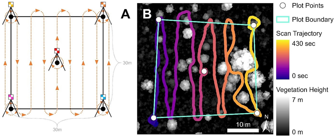
Comparing Mobile and Airborne Lidar's Abilities to Map Piñon-Juniper Tree Structure Piñon and juniper trees are among the most abundant speices throughout the American Southwest. Yet, their unique structure (short, irregularly-shaped, widely-spaced) makes them uniquely difficult to study using remote sensing. In this study, we compared the relative capacities of mobile and airborne lidar to quantify tree height, crown area, and aboveground biomass. At the stand level, mobile and airborne lidar yielded similar model performance; however, at the individual tree level, mobile lidar greatly outperformed airborne data. The results provide evidence of promise towards a future in which individual tree structure can be rapidly and accurately quantified in the field using mobile laser scanners, replacing slow and costly manual surveys.
Click here to access the published paper. |
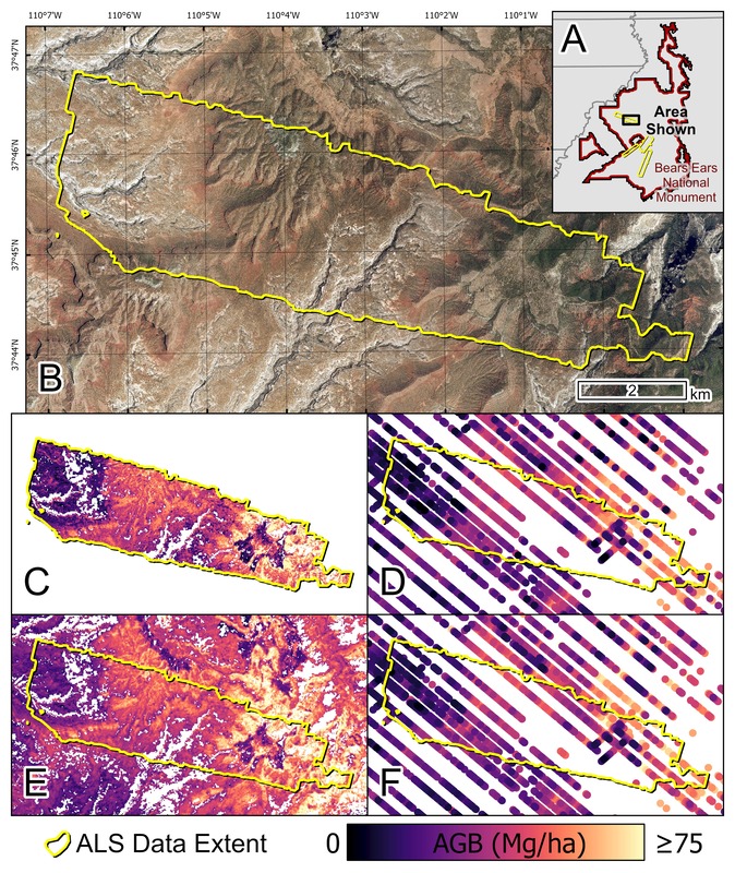
Multiscale Mapping of Piñon-Juniper Biomass: Comparing Landsat and GEDIThe recent launch of the Global Ecosystem Dynamics Investigation (GEDI), a spaceborne lidar sensor, provides new opportunities for mapping vegetation structure at a near-global scale. To test the extent to which GEDI could be used to map biomass in a dryland woodland ecosystem, we linked field-measured biomass to airborne lidar data to produce local-scale biomass maps. These biomass maps were then used to build a regional-scale model for estimating biomass, using both Landsat and GEDI. We found that Landsat surprisingly outperformed GEDI, producing more accurate and less variable biomass maps. These results highlight the structural uniqueness of piñon-juniper and other dryland woodland vegetation types, and suggest that tailored mapping approaches are necessary in these environments.
Click here to access the published paper. |
|
|
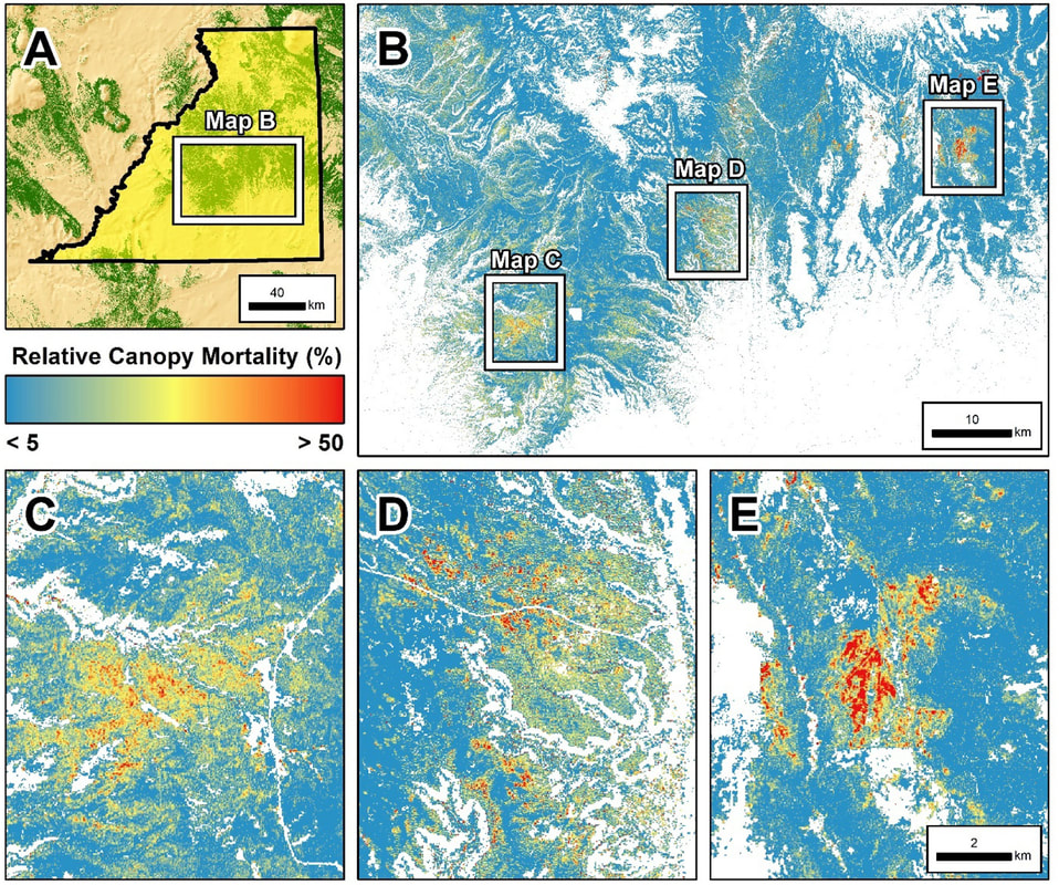
Mapping Woodland Tree Mortality using UAV, Lidar, and Landsat DataDryland woodland ecosystems span vast tracts of the globe and play a critical role in the carbon cycle. In piñon-juniper woodlands of the Southwestern US, recent droughts have resulted in widespread tree mortality. However, due to their unique structural nature, featuring small, widely-spaced trees and low canopy covers, these woodlands pose unique challenges to mapping mortality not faced in other forest ecosystems. To address these limitations, we developed a novel technique combining the analytical strengths of UAV high resolution aerial imagery, airborne lidar, and Landsat data to map the extent and severity of a recent mortality event in PJ woodlands of Southeastern Utah.
Click here to access the published paper. |
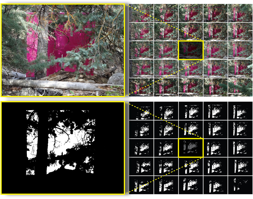
Quantifying Vegetation Density in the Forest Understory using LidarThe understory is a challenging place to work if most of your data are collected from the air and/or space. By its very nature, the understory is found beneath a canopy of trees, making synoptic remote sensing of understory structure difficult. One possible solution is found in lidar, given its unique ability to exploit small gaps in the forest canopy to reach underlying vegetation, but the extent to which understory vegetation density can be accurately mapped using lidar is not well known. In this study, we quantify the limitations of mapping understory vegetation density using lidar, providing an analytical framework for reliably and accurately mapping low-lying vegetation structure in forest and woodland ecosystems.
Click here to access the published paper. |
|
