WELCOMEWelcome to my website! Here you will find brief summaries of my professional interests and experience. The links above will guide you through various snapshots of the scientific journey I have been on for over a decade now. The journey has been a true joy, and I look forward to seeing what exciting twists and turns it takes in the years to come. As you'll see, my approach to scientific inquiry is one guided not by following a singular, well-worn path, but by continuing to explore and build new trails through diverse and challenging terrains. I appreciate you taking the time to check out my work, and I encourage you to reach out if anything you see sparks your interest.
To view my CV, click here. |
|
|
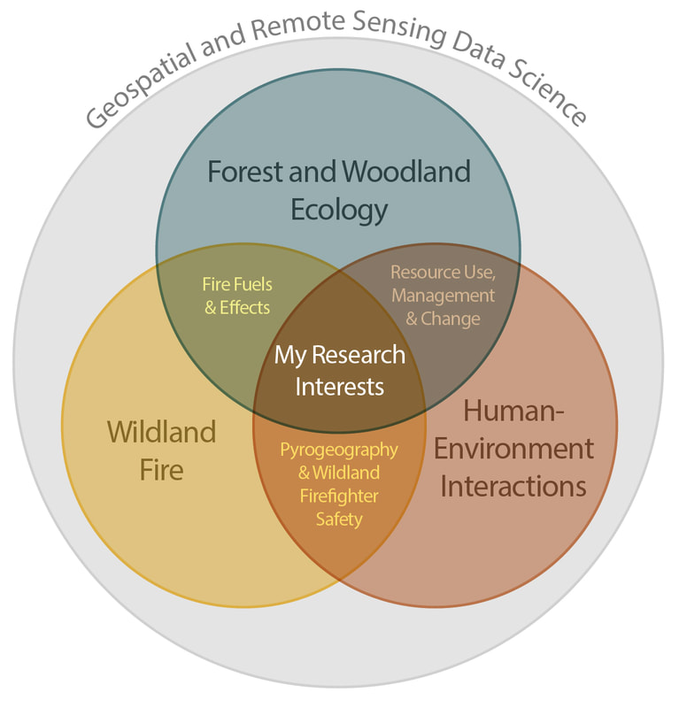
RESEARCHFirst and foremost, I am a remote sensing and geospatial data scientist. Developing novel, efficient, and elegant approaches to solving complex spatial problems is what keeps me excited and eager to grow as a researcher. I apply my craft to addressing relevant issues contained within the various intersections between wildland fire, forest and woodland ecology, and human-environment interactions. A foundational principle of the work I do is a focus on producing tangible, actionable results. I am not a "science for the sake of science" type of scholar -- I am someone who thrives working on projects that will have meaningful outcomes with clear impacts.
For more on my research, click here. |
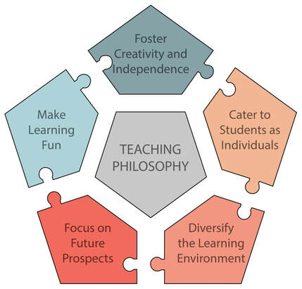
TEACHINGSome of my fondest experiences as a scientist have come not in the lab or in the field, but in the classroom. Working with, training, and getting to know students at all levels and from all backgrounds is truly one of the great perks of the academic life. I spent two and a half years as a teaching-focused, tenure-track Assistant Professor in the Department of Geosciences at Fort Lewis College in Durango, CO. It was there that I was able to hone my teaching craft and develop a solid pedagogical foundation upon which all of my courses are built. I have taught a wide range of introductory and advanced classes in GIS, remote sensing, Python programming, and pyrogeography.
For more on my teaching, click here. |
|
|
PROFESSIONALI am currently a Research Assistant Professor in the Department of Geography at the University of Utah. In this role, I am working on a variety of research with Dr. Phil Dennison and graduate students in the URSA Lab. Prior to my current appointment, I was an Assistant Professor in the Department of Geosciences at Fort Lewis College. During my PhD I worked as a GIS Analyst in the consulting space within the DIGIT Lab. I also worked for two years as a Remote Sensing Analyst for a US Forest Service contractor, RedCastle Resources, focused on vegetation type and structure mapping throughout the Intermountain West.
For more on my professional experience, click here. |
